 |
| Zigzag River and Canyon - July 14, 2015 |
When you make the drive from Portland to Mt. Hood on US 26, you pass through the tiny hamlet of Zigzag, just east of Welches. It's an odd name for a location and therefore easy to remember. There's also a Zigzag mountain, a Zigzag glacier, a Zigzag river, and of course a Zigzag canyon! I had often wondered about the history of this name, so lucky for you, I have done extensive research to answer this important question.
The first thing I discovered is that the name has nothing to do with the French tobacco products company, Zig-Zag. Apparently they are known for roll-your-own cigarette papers. Other non-starters that share the name are two movies, a magazine, a railroad, and a math code.
Digging a bit more, it seems that the catchy name was most likely derived from a comment made by our own Oregon pioneer, Joel Palmer. In October of 1845, he hiked through the yet unnamed Zigzag canyon. His journal noted how hikers must "zigzag" about to cross the steep canyon - presumably he meant using a switchback route to safely go up and down the canyon. Apparently the canyon and river were named first and then the community adopted it as well. The first and only Zigzag post office opened in 1917 and closed in 1974. Too bad, it would be fun to mail a postcard from Zigzag!
The Zigzag river is only about 12 miles long and feeds into the Sandy river near the community. Its water is mostly glacier and snow melt. The canyon, on the other hand, is much more impressive than the river, due to its depth and dramatic views. Geology fans will have a "field day" when hiking out to the canyon.
 |
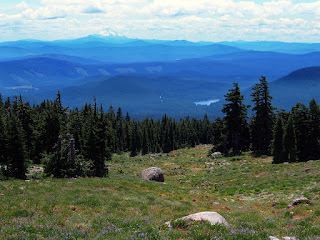
| Looking south - Mt. Jefferson and Trillium Lake in View |
To reach the canyon on a day hike, most folks start at Timberline Lodge. From there, you jump onto the Pacific Crest Trail and head west for about two miles to reach the canyon. On the way, you get great views to the south and go through Little Zigzag canyon before reaching the big one. It's a must do hike if you like volcanic subalpine terrain and want to spend a few hours taking in grand vistas as well as wildflowers.
 |
| Hikers climbing out of Little Zigzag Canyon |
The elevation at the rim of the canyon is about 6,000 feet, and the river is about 1,000 feet below. From the rim you can hear the roar of the river as it descends. The river drops 5,700 feet from its source to the end at the Sandy. Hikers who continue on the PCT must cross the river about a mile below the rim.
 |
| Zigzag Canyon (left) and PCT (right) |
On this day, the wildflowers in this area were notable but not spectacular. Many were already past their prime due to our early hot, dry summer. Nonetheless, I spotted about a dozen familiar faces along the way.
Subalpine Lupine and the very dry Little Zigzag Canyon
Sulphur Flower, early vs. late bloom color
Partridge Foot and Mt. Hood Pussypaws
Cascade Aster and Green False Hellebore
Subalpine Mariposa Lily and Pearly Everlasting with Canada Goldenrod
Links:
Joel Palmer Wiki
Hike Details


No comments:
Post a Comment